https://j.people.com.cn/n3/2026/0717/c95952-20478766.html
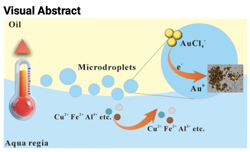
A new technology recovers gold from waste liquid using naturally occurring micro-droplets at the oil-water interface, simply by moderately heating the oil-water system—without the addition of any reducing agents, adsorbents, or catalysts.
The technology was developed by a team from the China University of Petroleum in Qingdao, in collaboration with researchers from Stanford University.
Drawing on their previous research into geological fluids—where they discovered that large numbers of chemically active micro-droplets are generated at oil-water interfaces under high-temperature conditions—the team formulated a bold hypothesis: “Could we selectively extract gold from complex waste liquids simply by utilizing the chemical properties of these micro-droplets?”
To test this, the team constructed a heat-driven oil-water interfacial reaction system. Moderate heating causes the continuous formation of micro-droplets (5–50 micrometers in diameter) at the oil-water interface. These droplets function like micro-reactors with high redox activity, continuously generating active species such as highly active electrons, hydrogen radicals, and hydroxyl radicals. This process enables the reduction of gold ions in the solution to elemental gold without the need for external reducing agents, catalysts, or adsorbents; furthermore, the coalescence and growth of these micro-droplets allow for the formation of millimeter-sized gold particles.
The study also elucidated the chemical mechanism by which the interfacial micro-droplets selectively recover gold. Experiments demonstrated gold recovery rates of 98.5% from complex aqua regia waste liquid and 97.0% from electronic waste leachate. The recovery time was further reduced through heating and cooling cycles, and a recovery efficiency of over 90% was maintained even when the oil phase was reused. In a scale-up experiment, 500 milliliters of gold-containing leachate were processed to yield 0.5657 grams of solid product. The gold achieved a purity of 99.4%, demonstrating high potential for application as an environmentally friendly technology for recovering precious metals from complex acidic wastewater.