https://www.cas.cn/cm/202602/t20260204_5099676.shtml
Extracts from an interview with Xu Xinwen, a researcher at the CAS Xinjiang Institute of Ecology and Geography.
In the 1990s, oil and gas resources were found in the Tarim Basin—the Taklamakan Desert.
This place was shrouded in sand, with no roads to be found. People couldn’t get in, supplies couldn’t get in, so how could development and construction be possible? Building a desert highway was urgently needed.
During the Eighth Five-Year Plan period (1991-95), the state proposed building a desert highway in the Taklamakan Desert. At that time, China still lacked the technology. A group of scholars specializing in highway construction and desertification control came to the area, including Xu Xinwen.
Although the route of the desert highway was initially drafted using remote sensing satellite images, aerial photographs, and other relevant data, the specific route needed to be refined based on the height of the sand dunes and wind direction. In addition, sand control systems had to be designed. Without a sand control system, the sand would quickly bury the roads. The height of the composite sand dunes in the Taklamakan Desert is generally between 50 and 70 meters, with some reaching over 100 meters.
Eventually, a topographic map nearly 500 meters wide was developed. At a scale of 1:2000, it covering an area of 200 meters on each side of the planned desert road. The data were relatively accurate, providing a scientific basis for subsequent sand control and prevention work.
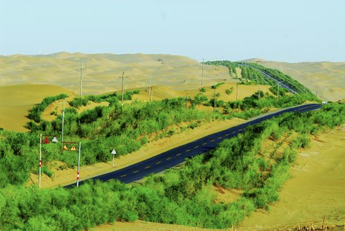
In 1995, a 446-kilometer highway traversing the Taklamakan Desert was completed. At the time, this was the world’s longest continuous highway crossing a shifting sand desert, providing crucial support for the exploration and development of oil and gas resources in the Tarim Basin. It was also known as the Tarim Desert Oil Highway.
For wind and sand disaster prevention, three measures were taken:
- biological sand control,
- mechanical sand control, and
- chemical sand control
It was decided to first adopt a mechanical sand control system. Because of the abundant local reed resources, reeds were used to construct mechanical protective systems ranging from 70 to 300 meters in width along both sides of the highway. As fast-moving sand crosses the sand-blocking fences, fills the straw checkerboard, and breaches the sand control system, the highway will be ultimately harmed. Therefore, it was decided to adopt a two-pronged approach: first, prioritize mechanical protection to ensure the highway’s construction and early operation; then, once the technology matured, replace mechanical protection with biological protection.
To establish a biological protection system in this “sea of death” was challenging. The region is arid year-round, with little rainfall, towering sand dunes, and no fresh water. Plant growth there is affected by multiple factors, including soil, groundwater, temperature, and hot, dry winds, requiring thorough research and experimentation.
Early in the construction of the desert highway, the team had simultaneously established a 15-acre experimental plot on the desert edge to conduct plant introduction and salt and drought tolerance tests. In 1994, when the desert highway reached the Tazhong Oilfield in the heart of the Taklamakan Desert, the experimental base was moved there to continue work on plant introduction, salt and drought tolerance, and seedling cultivation experiments. It was discovered that seedlings thriving in the ground didn’t guarantee their survival in the desert. A sandstorm would sweep in, burying the newly sprouted seedlings under shifting sands. As a consequence, mechanical sand barriers were placed around the nursery to protect the seedlings from wind and sandstorms.
After six years of exploration, several plant species, including tamarisk, were identified which can tolerate irrigation with more than 15 grams per liter of saline water, and saxaul, which can tolerate 28 grams per liter of saline water. Starting in 1997, the selected tree species were planted along both sides of the desert highway, beginning an experiment in building protective forests along desert highways. By 2000, a 6.3-kilometer-long biological sand-protection demonstration section had been built in the heart of the Taklamakan Desert.
In 2002, a 20 ha desert botanical garden was established in the heart of the Taklamakan Desert for the Tarim Oilfield. Over 400 plant species were planted and preserved over 200, providing abundant seed sources and seedlings for the subsequent construction of the shelterbelt system. In 2014, the Tarim Desert Highway was voted one of “China’s Top Ten Most Beautiful Highways” by netizens.
The completion of the Tarim Desert Highway shelterbelt had received high recognition from the international community and has also attracted the attention of relevant departments in Libya, a desert country in North Africa. At that time, the highways in southern Libya also faced severe sandstorms. In December 2006, Xu Xinwen was invited to Libya to share his technology and construction experience. The following year, Libyan experts visited China for on-site investigation and immediately invited a Chinese research team to help Libya build a desertification control center.
In 2007, the African Union adopted the “Great Green Wall of Africa” initiative, planning to establish a vegetation belt over 7,700 kilometers long and 15 kilometers wide in the Sahel region of sub-Saharan Africa. In September 2017, the Xinjiang Institute of Ecology and Geography was invited to sign a memorandum of understanding with the secretariat of the Pan-African “Great Green Wall” organization.
Xu Xinwen has two expectations:
- first, he hopes to make breakthroughs in new technologies and materials for sand control and desertification prevention, forming our own core technologies and products;
- second, he hopes to cultivate more young people who can not only accurately identify the hazards of wind and sand, master the technologies and material characteristics of sand control and desertification prevention, but also formulate practical and feasible desertification control plans according to different situations, enabling more young people to take on independent roles in desertification control work.
The photo shows part of the Tarim Desert Highway Shelterbelt